|
VANCOUVER, BC, EarthDaily Analytics ("EDA" or the "Company"), a vertically-integrated software and analytics space company revolutionizing the way companies go-to-market, announced today that deployment of its SaaS EarthPipeline ground segment by South Korea's Nara Space ("Nara") enabled the recently launched Observer-1A Satellite to produce an accurate first light orthorectified image more rapidly than would have been possible utilizing commercially available alternative systems.
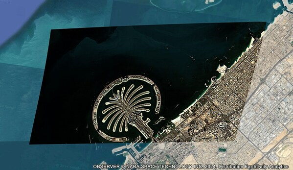
 Nara Space's first images at 1.5m resolution, processed by EarthDaily Analytics EarthPipeline. Image of Palm Jumeirah island in Dubai, UAE.
Production of a "first light" image is a critical milestone in the orbital deployment of an imaging satellite. This image represents the satellite's inaugural construction of an image following initial in-orbit testing of the various imaging components. From Nara's raw downlinked data, EDA orthorectifies the imagery, which is to say EDA implements a critical process in the creation of precise satellite imagery, ensuring that each pixel in the image corresponds accurately to its location on the Earth's surface. To orthorectify an image, the EarthPipeline characterizes all of the sensor and satellite properties including the focal length, optical distortion, star tracker mounting alignment and satellite stability. Through a combination of physics-based models and machine learning, EarthPipeline constructs a digital model of the Earth, satellite, and sensor, capturing the precise imaging geometry of each satellite image acquisition. EDA's meticulous approach not only enhances geolocation accuracy, however, but also improves radiometric calibration. EarthPipeline performs advanced radiometric calibration using specific calibration sites to translate pixel values into scientifically accurate signals describing the Earth's ground features. The combination of world-class orthorectification and radiometric calibration lead to Observer-1A's high-quality Analysis Ready Data products.
Jae-Pil Park, CEO of Nara Space, commented, "We believe that Nara Space has proudly asserted itself as the pioneer in the 25kg-class satellite arena, as we have achieved overseeing the entire satellite development process independently, from satellite manufacture to satellite imagery data analysis. With the successful launch of Observer-1A, we are ready to revolutionize industries including finance, environment, disaster management, and smart cities through our satellite data services. We plan to leverage our self-developed nanosatellite constellation in the near future to offer fast and precise data acquisition at a competitive price. The integration of our upcoming constellation with the EarthDaily Analytics EarthPipeline ground segment is a game-changer, significantly enhancing our data delivery capabilities as we deliver faster and more efficient market insights."
EDA's EarthPipeline is the world's first fully managed ground segment pipeline-as-a-service, enabling both EDA and external customers such as Nara Space to transform downlinked satellite data into high-quality, Analysis-Ready Data ("ARD") and imagery at a speed and scale previously unattainable with competitive technologies. Leveraging Amazon Web Services, EarthPipeline provides an endlessly scalable service that removes the pre-processing, normalization, and image transformation tasks from satellite operators' workflows, empowering them to reach the market up to three times faster with ARD that is ready to be used in AI and Machine Learning applications seamlessly and securely. Nara Space data processed by EarthPipeline will also be made available via the Earth Data Store for purchase.
Don Osborne, CEO of EarthDaily Analytics, stated, "It's no secret that high-quality data is a necessary precondition for high-quality analytics. Equally important, however, is the ability to process that downlinked data reliably and cost-effectively at a speed that brings the end user as close to real-time insight as is possible. Running on the best-in-class AWS platform, our industry-leading SaaS EarthPipeline ground segment is highly efficient, endlessly scalable, and – as proven today – capable of processing satellite-derived data with unmatched quality and turnaround time. In providing this service to third-party satellite operators, we are driving the state of the industry forward and bringing EDA's game-changing processing power to a New Space sector that increasingly appreciates the necessity of best-in-class efficiency, quality, scalability, and speed in an ever more competitive landscape. Following the launch of EDA's forthcoming EarthDaily Constellation in late 2024, EarthPipeline and AWS will play a crucial role in unlocking the full potential of Everywhere Everyday." |